

This post covers part one of solo backpacking the North Country Trail in Upper Michigan, on the 100-mile stretch between Marquette to Grand Marais.
As an Amazon Associate, I earn from qualifying purchases.
Who is Betsy Leighton?
I’m a writer, blogger, and healer dedicated to helping individuals reconnect with their innate peace and wholeness by healing nervous system dysregulation. My personal experience with chronic illness called Mast Cell Activation Syndrome (MCAS) shapes my work, and my content offers tools to empower those with chronic illness to improve their well-being and take charge of their health.
I created the Sacred Self-Healing Method and am a trained and certified Safe and Sound Protocol provider, an author, blogger, and A Course in Miracles Teacher. I hold a Master of Divinity in Spiritual Counseling and am a trained spiritual mentor, with certificates in sound healing, aromatherapy, nutrition, and Sacred Deathcare. I offer a self-study certificate program in the Sacred Self-Healing Method, provide spiritual counseling and coaching, courses, and supported subscriptions for the Safe and Sound Protocol.
What is MCAS?
Mast Cell Activation Syndrome (MCAS) is a chronic condition that affects all organ systems. It can cause severe, disabling symptoms every day, including potentially fatal anaphylaxis.
The common triggers for MCAS are infections, toxic exposures including mold exposure and EMFs, trauma, concussions, and stress.
MCAS often occurs with other chronic conditions like Ehlers-Danlos Syndrome (EDS) and Postural Orthostatic Tachycardia Syndrome (POTS). Managing MCAS is challenging because many healthcare providers are unaware of it, and diagnostic tests can be unreliable. Treatments include antihistamines and mast cell stabilizers in the form of medications and supplements, along with avoiding triggers. Check out this post on managing MCAS.
Why solo backpacking?
In 2024, I solo backpacked most of the Superior Hiking Trail and wrote a book about the experience. I have a chronic illness called Mast Cell Activation Syndrome (MCAS), which causes symptoms of severe inflammation, pain, and allergic-type reactions. I’ve managed my condition with dietary changes, antihistamines, and mast cell stabilizers. In solo backpacking, I’ve found a hobby that keeps me fit, challenges me, and actually helps me manage my symptoms. Over the past two years, I’ve gradually increased my exercise tolerance, starting from not being able to exercise at all. In June of 2024, I began solo backpacking the Superior Hiking Trail, and at that time, I could only walk one mile. As my stamina and strength grew, I increased my pack weight and mileage until I reached my furtherst daily distance of up to 38 miles.
I’ve done a lot of work to heal MCAS by treating infections and toxic mold exposure, improving my gut health, and retraining my nervous system. Along with those things, I found being in nature in sync with my circadian rhythm to be a huge piece of my healing path.
In 2025, I solo backpacked across northern Wisconsin in four sections on the NCT with the help of some trail angels who shuttled me from one trailhead to another. If you’re interested in reading about my past sections of the NCT, check out my blog: https://betsyleighton.com/solo-backpacking/
In 2026, I’m aiming to solo backpack the 550-mile section of the NCT in the Upper Peninsula of Michigan.
Why the North Country Trail?
The North Country Trail spans 4800 miles from North Dakota to Vermont, and traverses my home state of Minnesota. I was attracted to exploring the Superior Hiking Trail, which is a segment of the NCT in Minnesota, first because it holds fond memories from my childhood. But once I finished the SHT, I was hooked on solo backpacking and wanted to continue to explore the North Country Trail, where it picks up after the SHT at the Western border of Wisconsin. From there, I’ve set my sights on completing the entire NCT over the next few years, and I hope to solo backpack at least 500 miles per season.
Gear
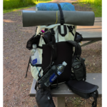
My backpack weight is usually about 20 pounds on a typical 3-day solo backpacking trip. My base weight is a little under 13 pounds–which includes my shelter (tent), sleep system (quilt, sleeping pad, inflatable pillow, etc.), and basic safety gear for first aid and gear repair. Food and water are the heaviest items in my pack, and they add another 7-10 pounds to my pack. You should really only carry 15% of your body weight on your back, so that limits what I can carry. I’ve tried a lot of different gear setups, and have found that with my petite 5’2″ frame and weight, it works best for me to use ultralight backpacking gear. You can check out my gear list here.
Sewing
With MCAS, I react to many fabrics, scents, foods, and textures. I’ve sewn a lot of my own backpacking clothing because it allows me to use the fabrics I tolerate and create fits that suit my style and comfort. You can check out my sewing projects here.
Tolerating exercise
This post covers the unique challenges to exercising when you have a chronic illness and offers tips and tricks I’ve found to make it work when you have physical limitations.
Day 1 NCT MI-UP Munising Falls Visitor Center to Chapel Road
If you’ve been following my solo backpacking journey on the North Country Trail, it’s time to tune in again! After months of training at home, I’m excited to share my adventures on the next leg of the NCT: the Upper Peninsula of Michigan. The NCT spans from North Dakota to Vermont, and the UP of MI section is 550 miles, stretching from the WI/MI border to the Mackinac Bridge at St. Ignace. From there, the trail crosses the bridge to Macincaw City before dipping into lower Michigan. I’m aiming to cover the UP section in six or so trips over the coming months.
To recap, in 2024, I solo backpacked most of the Superior Hiking Trail and wrote a book about the experience. I have a chronic illness called Mast Cell Activation Syndrome (MCAS), which causes symptoms of severe inflammation, pain, and allergic-type reactions. I’ve managed my condition with dietary changes, antihistamines, and mast cell stabilizers. In solo backpacking, I’ve found a hobby that keeps me fit, challenges me, and actually helps me manage my symptoms.
In 2025, I solo backpacked across northern Wisconsin in four sections on the NCT with the help of some trail angels who shuttled me from one trailhead to another. Thanks, Dom and Cindy!!
For this trip, I hoped to cover most of the Pictured Rocks National Lakeshore before high tourist season. David joined me on this trip, and we made an inn in Munising, MI, our home base for three days. On Saturday, we left the Munising Falls trailhead at 8 AM and discovered the trail was fairly muddy right away. There was spring flooding near Munising Falls, so part of that trail was closed, but the NCT was accessible.
David hiked with me for the first 2 miles, and then he headed back to the car. The morning hike featured lots of downed trees and tons of mud. At one point, I fell face-first into a muddy creek because it was so slick
All morning, I only saw one other couple on the trail close to Munising Falls. But when I arrived at the Miners Castle trailhead, I encountered tons of day hikers, tourists, and then a group of male “heavy” backpackers. I say “heavy” because they had very heavy-looking packs.
After Miner’s Point, the trail dipped down to the shore. Before that, the trail had meandered up high along cliffs over Lake Superior with views of the waters below. Close to the shore, the water is greenish like the Caribbean, and today it was so windy that whitecaps dotted each wave.
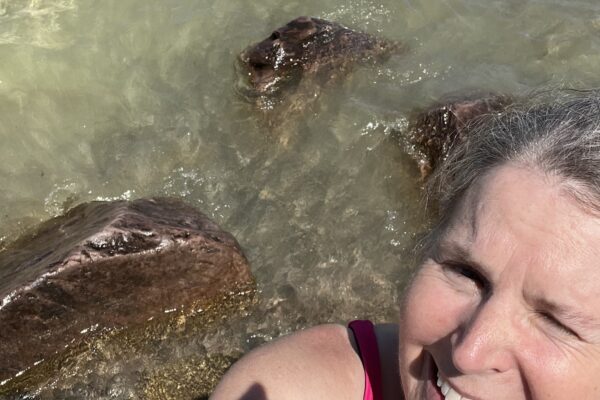
Along Miner’s Beach, the trail skirted right along the white sandy shore, and it was magnificent. I walked right into the lake to clean the mud off my shoes and my legs. It was refreshing to cool off in the water.
After that, I continued Northeast on the trail through wooded areas where the entire forest floor was covered in wild ramps. I startled three deer at one point, who were much more cautious around people than the ones I have been encountering on my training hikes at Afton State Park near my home.
I met another group of heavy backpackers, and one of them questioned me about how far it was to the Miner’s Castle parking lot several times. He seemed like he was on his last rope and needed reassurance that the end was near.
While I was at Miner’s Castle, I ate my lunch and then lay down on a bench to rest my legs on my pack, elevating my feet, before continuing on. There was still unmelted snow on parts of the beach!
Next on the trail, I approached the Mosquito Beach area, where there are campsites and day-hiking trails. The last section of the Mosquito Beach area had tons of mud and by the time I made it to the car, my feet were sodden again. David arrived right away and met me in the parking lot. There were hundreds of cars at that trailhead and I had been a little bit worried about meeting up with him, but luckily, I saw him right away.
In training, the longest distance I had completed was about eight miles, and the last couple of miles of the day were tough as my body started seizing up a bit, so it was the right time to stop. But luckily, I had no blisters, my body felt good all day, and it was a gorgeous hike.
As we drove back to Munising, we passed a Dairy Queen and decided to indulge in hot fudge sundaes with fudge, whipped cream, and pecans. Yum! After I cleaned up with a shower at the inn, we headed out to dinner at a burger place, and I enjoyed a chicken burger with spicy peach chutney. Delicious! Since the official tourist season starts on Memorial Day weekend, many of the local restaurants are not yet open. But we enjoyed homemade gluten-free pasties yesterday at another open eatery.
All in all, it was an excellent day and a good start to my journey on the North Country Trail in the Upper Peninsula of Michigan. I had covered 14 miles in six hours and felt like I was on my way to an excellent season.
Day 2 NCT MI-UP Chapel Road to Little Beaver
Today’s hike began at the Beaver Lake Trailhead about 38 miles east of Munising. I planned to hike 12 miles from here to the Chapel Road Trailhead, where I’d left off yesterday.
The first part of the Beaver Lake wilderness, leaving the parking lot, was stunning, through mature white pine forest along the Beaver River and passing Beaver Lake. I saw five “heavy” backpackers before the trail met the shoreline. On day one, I had been very comfortable in running shorts and a sun hoodie, but as soon as the fresh breeze off the lake hit me today, I needed to add some layers to stay warm enough.
Once the spur trail joined the NCT at the lakeshore, the terrain alternated between hugging the shoreline and dipping into the woods. There were dozens of spectacular vistas up and down the shore, with stunning green water, magnificent cliffs, sandy beaches, and rocky outcroppings. I heard loudspeakers from a tour boat echoing off the cliffs from time to time.
After about 4 miles, I met a kindred spirit: another solo female backpacker! She said she was on the third day of her hike, and she looked ready to get off the trail. She had that look about her from extended solitary hiking—a look I knew well from when I hadn’t talked to anyone in days, and couldn’t easily organize my thoughts to have a conversation when I met another person on the trail. We shared some highlights from our hikes and then said goodbye.
The next stretch of trail headed into the woods, where sand had blown from the beach to cover the forest floor. It alternated with sandier and muddier sections at times. Some parts were dry and dune-y, while others had black mud.
I stopped to eat lunch at Chapel Rock, a stunning piece of rock carved from the shoreline and surrounded by water, with a large tree growing on the top of it. The tree’s roots stretched across the water to sink into soil on the mainland. From there on, as I hiked to the Chapel Rock trailhead, I encountered dozens of day hikers.
It began to rain just as I took the 3-mile spur trail away from the lakeshore, and as I retraced that section to meet David again, the rain fell more heavily, and the mud worsened. But I was wearing the set of Fabshell ultralight rain gear that I sewed, and I stayed warm and dry until the end.
After meeting David at the trailhead, I took a bath to warm up at the inn, and then we had dinner at the nearby Buckhorn Resort. It was a great end to the day!
The weather will continue cold and wet tomorrow, so we’ll be heading home to Woodbury. I knew I wouldn’t have time on this trip to complete the entire 42-mile Pictured Rocks shoreline, so I’m planning future trips to finish it up and cover other sections of the NCT.
Day 3 NCT MI-UP Little Beaver to Benchmark
As I planned my next section on the NCT, I was constrained by several factors. One was that I had a volunteer driver willing to drive me from Munising, Michigan, to Marquette, Michigan, on Memorial Day. Two, I could only land a campsite on the pictured rocks Lakeshore at the Benchmark campsite on Friday.
I was also concerned about completing the entire 8-hour drive on Friday and arriving in time for my shuttle within the park Friday afternoon because of (1) holiday traffic since it was Memorial day weekend, (2) I was going to lose an hour when I crossed into the Eastern time zone; (3) was about 200 miles of construction on the route through Green Bay, so I was opting to take the northern route; and (4) I just wanted to lessen the stress of the trip. So to make it all work, on Thursday, I drove 4 hours to Ironwood, Michigan, and camped at the Curry Park campground Drove halfway from the Twin Cities. Then on Friday morning, I drove from Ironwood to Pictured Rocks.
Weather forecasts were encouraging because in Ironwood, even though the overnight temperature dropped to 41°F, that was expected to be the lowest temperature I would experience all week. There was also no rain forecast at this time for the upcoming week.
I stopped at a food co-op in Marquette and got some lunch. Unfortunately, they didn’t have much in the way of gluten-free options in their deli, so I opted for sushi.
I had a minor freak out when I arrived in Pictured Rocks because I realized I had never gotten a confirmation of my Shuttle reservation, and I didn’t have cell signal when I got to the trailhead. So I decided to drive west until I had a cell signal to call the shuttle company for confirmation.
After my freak out about time zones and shuttle pick up locations, I ended up at the Grand Sable visitor center early, and the shuttle driver arrived, cheerful, and early as well. I was grateful to finally be where I was supposed to be after navigating all of those contingencies, and relaxed in the shuttle for the 40-minute drive back to the Little Beaver trailhead. As we drove, we picked up one other backpacker, a young guy with an exceedingly heavy backpack and a full fishing rod and reel.
Once at Little Beaver, I thanked the driver and set off into the woods again, retracing the steps I had taken five days earlier to tour the lake. This time, when I came to the shoreline, I went east toward 12-mile beach. This section of the trail was absolutely stunning, following along the shoreline with ample shade trees, gorgeous white sand, beaches, and pleasant waves lapping the shore.
Along the trail, I passed several day hikers and heavy hikers, and after a bit, I was blissfully by myself again on the trail.
The trail bed was often sandy, and it was lined with scrubby bushes that scratched at my legs every once in a while. After my hike ended last weekend, I returned home with scratched-up legs, and it looked like I was in for more of that.
The weather was beautiful, cloudless, sunny, and there was a little breeze to help cool things off. And occasionally I hiked over snowfields that hadn’t melt yet melted yet.
The sun set about 9:20 PM, so I had plenty of daylight to finish my 12-mile hike to Benchmark. The last mile took me through the 12-mile beach campground. After not seeing anyone for four hours, it was a bit surreal to come upon a full campground with RVs and swarming with people. But after the campground, the trail headed back into the woods and shortly thereafter, I came to Benchmark, a backpacking-only campsite with six sites. Four other people were camping in the adjacent site, but it didn’t feel crowded.
I set up camp, read my book, and fell asleep. I was cozy with my new ZenBivy ultralight sheet attached to my sleeping quilt. I really love how it covers my head like a hood and eliminates the drafts on the sides of my quilt. I slept great!
Day 4 NCT MI-UP Benchmark to Grand Sable Visitor Center
I woke about 6:30 AM after having a cozy sleep in my tent. It was overcast, and I started noticing a few gnats and sandflies around my face while I was cooking breakfast, but the main bug season has not started yet, hallelujah. There was a nice breeze to keep the bugs away from my face as I made my tea, and had my breakfast.
This is the first time I camped in a sandy area, and so as I was packing up that morning, I had to shake out quite a bit of sand from my socks, shoes, and tent. It wasn’t a lot, but it got everywhere.
As I headed toward Hurricane Ridge, the trail meandered into the woods, and I climbed up a ridge.
Yesterday, when I filtered water for the first time through my Sawyer squeeze this season, I had a lot of trouble getting the water to flow. But luckily, by this morning, when I needed to filter more water, it flowed through freely.
This morning, I was also testing out my marine airhorn canister fuel hack for the first time. It’s a way to save weight when ultralight backpacking, where you take a small marine airhorn canister, empty out the propellant, and refill it with isobutane fuel to use with your burner. It saves about 100 grams in weight, and it took about 10 minutes to boil a couple cup of water. It worked great, and it appears I have enough fuel in one little cannister to boil at least a cup of water twice, maybe even three times per canister; we’ll see.
On this trip, I’m wearing my full backpack weight, which is another first for the season. Last weekend, I was slack-packing— wearing my day pack and not carrying my shelter or sleeping setup, so it was lighter. I was also not carrying as much food. My base pack weight is 12.5 lbs, and I weighed my pack before I departed the Twin Cities; my pack weighed 22 pounds. It’s a little less now because I’ve eaten and drunk some of that weight. But I am adjusting to carrying more weight on my back and noticing my shoulders are a little bit tender near the armpits where my shoulder straps hit. This backpack is super comfortable, and it’s not painful. It’s just my body getting used to carrying the weight again.
In terms of apparel, I am also trying out a new Marino Sun hoodie, and it has been fabulous. In the hot sun, it shades my skin with SPF, and in cooler weather, it keeps me warm.
I’m also trying out my Durston Iceline trekking pole for the first time. I switched to this pole because it’s a little bit lighter than the REI pole I had been using, and it has the added benefit that I can use it for two different things: one is for balance while I’m hiking, and the other is as a support for my tent at night, eliminating the need for an extra tent pole.
Spring has not completely sprung here in the Upper Peninsula yet, and many of the trees have not leafed out yet, so there’s a barren feeling in the woods. But I’m noticing more signs of spring compared to last week, when I did part one of the Pictured Rocks Lakeshore.
Along with leafing trees comes tree pollen, and last week I had to take several extra doses of my mast cell stabilizers to deal with the extra allergic response. I’m noticing that again this time, but I’m also feeling like my body is less reactive than when I solo backpacked last October. I’m feeling less inflammation, more stamina, and strength, and more flexibility, especially in my spine.
Today’s trail section featured stunning high cliffs of dunes threatening to tumble down into the water. The entire cliffside looked like it was holding on by a thread, and one false move could lead a hiker to tumble down hundreds of feet to the lake. I was careful and stayed away from the edge.
After leaving that section, the trail wound inland through 3 miles of enchanted forest. Enchanted because the forest floor was covered with tiny pink flowers for miles in all directions. I passed a young deer, staring at me in the forest.
After that, the trail reached Sable Lake and skirted around the northern edge. At the top of the lake, where it drained toward Lake superior there was quite a bit of black mud, but it was only a small stretch and was easily crossed on logs. Finally, the trail traversed a prairie before winding back to the Grand Sable visitor center.
I saw a couple of groups of backpackers heading west, but no solo backpackers, and no women on this section.
It was a bittersweet ending to the Pictured Rocks Lakeshore section of the North Country Trail. It has been stunningly beautiful with magnificent, easily accessible trails, and nice amenities for camping. But I look forward to the next section I will be covering between Marquette and Munising.
Day 5 NCT MI-UP Grand Sable Visitor Center to Grand Marais
I slept at the Muscallonge Lake State Park campground overnight and camped in my car. I was glad to have more shelter than a tent because there was a wicked wind blowing across the lake, gusting to 30 miles per hour. It had been dry the last several days, and the gravel road out to the campground was so dusty that I had to keep a quarter-mile distance away from other cars so that I could see the road as I drove and the dust swirled. Luckily, it rained a little overnight, helping the dust to settle, and the wind dropped overnight as well.
Today was an easy day of hiking because I was between sections. I lazed in my sleeping bag in the car for a couple of hours reading my book before I checked out around 10 AM and headed to Grand Marais (MI).
I hiked the NCT between Grand Marais and the Grand Sable visitor center, a little over 5 miles starting from downtown Grand Marais. As it left the town, the trail headed onto a rocky beach for a 1-mile stretch. It was a reminder—like when walking on a sandy beach—that it works best when I just settle in and take my time. If I try to go fast, it only makes the journey harder.
On my first pass along the rocky beach, I realized I had two bars of cell service, so I called my husband and checked in with him. He’s been in Los Angeles, helping his mom, and it was good to catch up. After that, I checked my email and continued on.
There were tons of tourists on the trail leaving the beach as it followed a river to a falls, but beyond that, the trail emptied again as it approached the visitor center. I ran into a patch of friendly neighborhood poison ivy and carefully avoided touching it. Then, on the way back, crossing the Rocky Beach again, I talked to a woman and her mother who were hunting for agates. I remembered the many hours spent Agate hunting as a kid with my family along the shores of Lake Superior, but I didn’t end up finding any today. The best speed for walking a rocky beach is agate-hunting speed, looking down at all the rocks as I pass. If I try to hurry, I end up struggling.
I’ve been pleasantly surprised that, despite it being Memorial Day weekend, it has been pretty easy to find solitude. The rock hunters on the mile-long beach clustered where the trail entered the beach, and didn’t venture too far away. So it was easy to get away from the crowds and find my alone time on the trail. And that’s been true this whole weekend. There have been crowds clustered at the more popular trailheads and campgrounds, but a mile away, there is nobody else but me. Just how I like it!
Day 6 NCT MI-UP Marquette to Rock River
After leaving Grand Marais, I drove to Munising and ate a salad for dinner. I crave fresh vegetables out on the trail, when all I can eat are nutrient-dense dehydrated foods. So that salad tasted awesome!
I checked into a Quality Inn in Munising, but quickly realized that the room had black mold in the bathroom. I spoke with the front desk and was informed that the hotel is closed over the winter and had just reopened, so it was a known issue. Luckily, I was able to check out, get a full refund, and I found a comparable room nearby.
At the hotel, I washed my hiking clothes in the sink and hung them to dry, cleaned up and organized my gear, and rested, did yoga, and read my book.
When I backpack, I save weight by only wearing one hiking outfit. I carry a set of sleep clothes that I wear at night, but this minimalist approach saves weight, and I’ve learned that I really don’t need more clothes on the trail. Backpackers call it “embracing the stink”. I just suck it up and put those dirty clothes on that day. It makes a shower and clean clothes feel that much better when I come off the trail!
Today I was catching a ride at the Munising Falls visitor center parking lot from a trail volunteer named Ben. He is an NCT trail section steward in the western section, and he was just completing a backpacking the Pictured Rocks National Lakeshore that day. So it worked out well to get a ride with him west to Marquette.
I got some clear, intuitive hits about connecting with Ben that reminded me how powerful my intuition is when I notice the hits. Sunday evening, after eating dinner, I stopped at the Munising Falls visitor center parking lot just to gauge how full it was and how easy it would be to get a parking space the following day when I was meeting Ben. There was a small car in the corner of the lot that was energetically tugging on me, telling me it was Ben’s car. I haven’t met Ben or seen his car so I filed that information away.
This morning, I checked out of the hotel, stopped at the only diner in town that was open, and then my intuition told me to go check out the parking lot again. It was only 11 AM, and I was not expected to meet Ben until 1 PM (when he thought he would be coming off the trail), but as I approached the parking lot, a guy was sitting next to that car who looked like he had just finished section hiking the Lakeshore. So I stopped and asked him, “Are you Ben?”
So my intuition was correct that it was Ben‘s car parked in the corner of the lot, and it also correctly guided me to meet him two hours earlier than the time that he was originally expecting to come off the trail.
He was as pleased as I was that we had met up earlier, and after he did a little reorganizing of his gear, I put my backpack in the back of his car, and we headed toward Marquette.
He dropped me at a spur trail right off of Highway 28 outside of Marquette, where I joined the NCT and started my section hike. Right away, I noticed that it was hotter than I had experienced up to this point in MI, and I guzzled 2 Liters of electrolyte water over the span of four hours because I was sweating so much.
I stopped several times to filter water when I encountered water sources like creeks, and I noticed my Sawyer squeeze water filter was very sluggish again. I spent 30 minutes filtering about 500 mL of water at two different spots, until I decided it would be much more efficient to fill up my water bladder and let gravity drip the water through the filter while I walked. So over the next hour, I filtered another liter of water.
At 6 PM, just as I was putting my filter away. I began to hear thunder rumbling in the distance, and within a short time, it started to rain. But at that point, I had been so hot that the rain felt cooling. I continued to hike in the rain for another couple of hours until it stopped when I reached Laughing Whitefish State Park. It had been a contingency spot for me to consider camping for the night, but it was far too wet and buggy to camp there, so I kept going while I still had daylight.
Speaking of bugs, I had not experienced any bugs on the entire 43 miles of the Pictured Rocks Lakeshore Trail, but the mosquitoes were out in force. I immediately had to don my bug suit to survive the onslaught. And it wasn’t even effective enough to wear my bug shirt, so I wore my rain/wind jacket instead, which is impervious to bugs, but hot.
I’m discovering that the North Country Trail in the UP of Michigan is not as well-developed as the Superior Hiking Trail. On the SHT, there’s no question where the trail goes, because so many thousands of feet have trodden on it, creating a well-worn groove to follow.
But here the trail is very well marked with blue blazes on trees, thankfully, because the trail itself is not obvious to follow. Luckily, the blue blazers come at short intervals, and whenever I don’t have one in my line of sight, I know I’ve gotten off the trail.
I ended up covering 18 miles that day. I started looking for a suitable place to camp, starting at 12 miles, but it was too wet and swampy. I finally set up my tent at the intersection of two remote ATV trails because it was flat and it offered a spot with good drainage compared to the miles of swamp I had traversed.
Day 7 NCT MI-UP Rock River to Valley Spur
I mentioned yesterday that on Day 6, I ended up camping on an ATV road. Unfortunately, it was not a restful night. I kept swatting mosquitoes in my tent for hours, and it seemed like no matter how many I swatted, there was an endless supply. I suspect that my sopping wet socks must have been impregnated with mosquito larvae from slogging through the swamp, and those mosquitoes must’ve been hatching out in my tent throughout the night, providing endless annoyance. So yeah, ick.
At 4 AM, I awoke hearing a vehicle in the distance, and I really didn’t want to encounter any ATVers out there. So I packed up and started hiking on the ATV road by about 4:30 AM.
The roadwalk only lasted about a mile, and then around Rock River Road and mile 309, the trail thrust into swampy woods with tons of downed trees. I struggled through that part, only traveling a half mile in an hour, because it was so hard to navigate around the trees, muddy swamp land, while my gear was constantly snagged by blackberry canes. Once I got past that section, I was so relieved. That section was so poorly maintained that I only saw a few blazes on the trees, and some of them were very old red ones rather than the characteristic blue blazes. But in any case, so happy to have that behind me.
At first light, the mosquitoes had gotten very bad again, and I needed to get out my bug head net. It was just a little hard to see through it until there was enough daylight.
I continued, and my shoes and gear were actually dry by the time I had to ford a creek around 4 pm. There was no bridge or way around it, so it was wet feet again. Not my fav.
By 5 pm, I had covered a total of 23 miles that day and dispersed camped in Hiawatha National Forest. Dispersed camping is the practice of setting up camp on public land outside of designated, developed campgrounds. Dispersed camping is free and lacks any amenities. You just have to follow certain rules, like being off the trail, a certain distance from the road and water sources, and you have to follow Leave No Trace guidelines.
It was a comfortable spot, and I was happy for the rest!
Day 8 NCT MI-UP Valley Spur to Munising Falls Visitor Center
To recap, this trip was broken into two segments: (1) finishing the second half of the 43-mile Pictured Rocks National Lakeshore and (2) hiking from Marquette to Munising. I’ve achieved the first part, and now I am on part two.
As I prepared for this trip, I had in mind that I was ready to stretch my capacity as a solo backpacker. Over the past two years, I have gradually transformed from a day-hiker into a thru-hiker. I’ve followed dozens of thru-hikers’ journies on the Appalachian Trail, the Pacific Crest Trail, the Continental Divide Trail, and the Arizona Trail on YouTube. I’ve read blogs and books about thru-hiking, and gradually, I have started to see it as a possibility for me to embrace thru-hiking.
Thru-hikers typically spend multiple days on trail, covering as many miles as possible, constrained mostly by the number of days’ worth of food they can carry on their backs. Then they resupply at a nearby town and resume their journey. They call it a “zero” day when they regroup off the trail and thus cover zero miles that day.
Up to this point, I’ve done roughly 50 miles over a 4-day section at a time, and I’ve gone home to regroup in between sections. This trip is my first attempt at combining two sections ala thru-hiking. So my stay at a hotel last night was a simulation of regrouping between thru-hiking sections. My first Zero!
The next frontier will be planning multiple sections with pre-prepared food drops that I’ll pick up on zero days. It saves a lot of time and gas to stay close to the trail and string sections together into a longer trip. And that’s what I’m aiming for soon. But in the meantime, this trip is giving me a taste of what it is like to thru-hike.
In this section, I’ve also been ramping up my mileage closer to 20 miles per day.
The main impediments to thru-hiking for me are managing my chronic Mast Cell condition, controlling inflammation, and continually tweaking the foods that I tolerate. Many thru-hikers subsist on junk food, such as Cheez-Its, Snickers bars, and Pop-Tarts. But my situation is worlds different. I need to get enough protein to fuel my body while avoiding high-sulfur foods as much as possible. No easy task since most processed and dehydrated foods are high in sulfur. High-sulfur foods trigger terrible inflammation and pain in my body, so it’s not something I can ignore and power through. My nutrition plan is a delicate balancing act of maximizing nutrient-dense foods, consuming higher sulfur foods like nuts and dried cheese earlier in the day to have more time to metabolize them before sleep, and proactively dealing with the inevitable inflammation.
Taking Epsom salt baths is the easiest way to combat my sulfur-cycle dysfunction, but alas, I can’t take baths on the trail! This trip, I did take Epsom salt foot baths using a bucket at camp sites when I camped in my car. And that did the trick. But I can’t carry pounds of Epsom salt and a bucket on the trail.
So, the next part of figuring out this puzzle will be planning out days to do Epsom salt footbaths on zero days between sections of the trail. I’ll be figuring out how long I can last between Epsom salt footbaths, while maximizing mileage and consuming therapeutic foods. For me, it’s so much more than just deciding I want to thru-hike and throwing together junk food. But I’m up for the challenge!
Back to the backpacking tale …
I woke up near the Valley Spur Mountain bike trailhead, where I had slept in the Hiawatha National Forest. I had the best sleep of the whole week last night, which makes such a huge difference! I didn’t have a campsite, because I was dispersed camping in the national Forest, but I found a nice spot that was on a rise, that was relatively flat, relatively quiet, and felt safe.
I woke up at 5 AM with the sun and packed up my gear for the final 9-mile push back to my car. When I got to the Little Spur mountain biking trailhead proper, I was delighted to see that it had a bathroom with lights and heat and a trash can–luxury!– so I deposited the small zip-top trash bag that I had been carrying with me, as well as did a quick cleanup. Then, the trail meandered through the mountain biking trail system in a very well-mapped and well-marked fashion.
After that, the trail joined an area that had been recently logged, which was difficult to follow. Trail markers were painted on stumps slow to the ground, or flagged with pink tape on small tree branches. I took a couple of small wrong turns in the clear-cut area because it was not very well marked.
Then the trail descended through the Wagner Falls State Park area, before dumping out onto Michigan State Highway 28 for a road walk the last 3 miles to my car. I stowed my trekking pole, ate a snack, and then soldiered on. Luckily, there was a very wide shoulder on both sides of the highway, and it felt relatively safe.
I indulged myself on this last 9-mile stretch by listening to my “bad ass bitches” playlist on Spotify. Usually, I am trying to conserve battery life on my phone. But I knew I’d soon be back to civilization, and my music really helped motivate me for the last several miles.
Next in my sights, solo backpacking the North Country Trail in Upper Michigan will be a section near the western border of Wisconsin. I have a trail angel lined up to give me a ride from Presque Isle and Superior Falls. Thank you in advance, Susan!
I have to say, yesterday, when I was completely mired in blown-down trees and deep mud, and being snagged by blackberry brambles with every step, while being eaten alive by mosquitoes, I was considering quitting this whole darn thing. But yesterday, the afternoon’s hike was so beautiful, where I camped last night was stunning, peaceful, and rejuvenating, and my spirits have lifted, so I will be continuing.
I had been dreaming of having another Yooper pastie as my reward for this trip. Once I reached the Munising Falls Visitors Center, where my car was parked, I organized my gear and stopped at Miner’s Pasties for a gluten-free pastie on the way out of Munising. So good!
I started the 8+ hour drive home taking the northern route, and while filling up on gas in Ironwood, MI, I discovered I had an attached tick on my back in a spot where I couldn’t reach it. I quickly problem-solved, found a walk-in clinic, was seen immediately, and was on my way home with a prescription within the hour. This isn’t my first rodeo with tick-borne illness, and I now have a system in place for when I get reinfected. If you’d like to read my blog post about dealing with tick bites, I’ll link it in the comments.
Thanks for following along!
The bucket theory
The bucket theory simplifies understanding symptom reactions with MCAS. Imagine your body as an empty bucket you don’t want to overflow. Reactions to various stimuli fill the histamine bucket at different rates, forming the total histamine level (how full your bucket is). More histamine means more symptoms. By managing triggers, reducing exposures, and taking medications and supplements, you can control your bucket’s level.
Know your typical symptom progression
Understanding your symptom progression during a flare is key to developing your rescue plan. This post discusses how to recognize symptom progression so you can be prepared to address them.
Get my free ebook, symptom log, and meal plan!
Want a tool to easily track your symptoms?
Check out these circadian health tools!
I’m an affiliate with Bon Charge, a company that makes tools for circadian health, and you can receive 15% off your order with my coupon code BETSYL.
Bon Charge offers tools such as yellow– and red-tone blue-blocking glasses, red light therapy devices, PEMF mats, infrared saunas, and EMF-blocking products.
Sign up for the SSP!
I’ve found the Safe and Sound Protocol (SSP) to be the most helpful bottom-up healing strategy if your nervous system has been overloaded with toxic exposures, including mold or non-native EMFs, chronic infections, concussions, stress, or trauma. The SSP is a passive listening therapy that helps heal nervous system dysregulation. Many people with MCAS and other chronic conditions have nervous system dysregulation stemming from infections, toxic exposures, concussions, and trauma. The SSP is an easy-to-use app that lets you listen to specially filtered music for 30 minutes each day as part of a 5-hour cycle. Studies show the SSP has a profound effect on mental health and chronic conditions. Here’s a short podcast describing the Safe and Sound Protocol.
You can sign up for the SSP here!
Heal your mind!
While the SSP is a bottom-up, somatic therapy for healing the nervous system, the Sacred Self-Healing Method I offer is a top-down nervous system-healing modality that focuses on cognition, attention, perception, and emotion, using the mind’s higher functions. The SSP and the Sacred Self-Healing Method complement each other and together produce lasting results. Here’s a short podcast on my self-healing practice.
I provide one-on-one in-person and remote chronic illness and caregiver coaching, as well as Sacred Self-Healing Sessions based on the Sacred Self-Healing Method, a proven, novel co-creative healing modality detailed in my Books.
Order my books!
Here’s a short podcast highlighting my five books.
My latest book, Living In The Light: Healing with Forgiveness, Sound, and Light, is all about the tools that have been most helpful for me to heal: forgiveness, sound, through nervous system retraining using the Safe and Sound Protocol, and light, through entraining my circadian rhythm with the energy of the sun. Living In The Light is available here!
Rocks and Roots chronicles my solo backpacking journey on the Superior Hiking Trail and my efforts to overcome nervous system dysregulation, gut dysbiosis, and Mast Cell Activation Syndrome symptoms to complete the 328-mile hike successfully.
The Sacred Self-Healing Method ebook is available here and in most ebook retailers!
The Sacred Self-Healing Workbook is available for purchase here!
Betsy’s first book, Sacred Self-Healing: Finding Peace Through Forgiveness, is available here
Companion Recordings
The companion audio recordings of chants, guided meditations, and sound healing demonstrations that accompany the Sacred Self-Healing Method are available for free on my YouTube channel here
What do you think?
I’d love to have your reply below!
Disclaimer
The preceding material does not constitute medical advice. This information is for information purposes only and is not intended to be a substitute for professional medical advice, diagnosis, cure, or treatment.